Types of Clouds Know Their Types, Formation and Importance Explained: Meaning, Importance & Applications
Lesson Overview
Every day, clouds drift silently above us-shaping weather, signaling storms, or simply painting the sky. But have you ever wondered what they really are or why they form in different shapes? This Types of Clouds Lesson: Know Their Types, Formation and Importance unpacks the science behind clouds, explaining how they develop, the different categories they fall into, and their vital role in Earth's weather and climate.
What Are Clouds?
Clouds are collections of tiny water droplets or ice crystals that form when water vapor in the air cools and condenses. This process typically occurs when warm, moist air rises and cools in the atmosphere. As the air cools, it reaches a point where it can no longer hold all the water vapor, leading to the formation of clouds. These collections of water droplets or ice crystals become visible in the sky as clouds. Clouds play a vital role in the Earth's weather systems by regulating temperatures, influencing precipitation, and acting as indicators of weather changes. They come in various shapes and sizes, each type providing clues about atmospheric conditions.
What Is Cloud Formation?
Cloud formation is the process by which tiny water droplets or ice crystals group together and become visible in the sky as clouds. This occurs when warm, moist air rises, cools, and condenses into water droplets or ice, depending on the temperature.
Here's a breakdown of how this natural process works:
1. Evaporation Adds Moisture to the Air
Water from oceans, lakes, rivers, and plants evaporates into water vapor due to the heat of the Sun. This vapor mixes with air and becomes invisible but still present in the atmosphere.
2. Rising Air Cools with Altitude
As air containing water vapor rises into the atmosphere-often due to heating from the surface or being forced over mountains-it expands and cools. Cooler air holds less moisture.
3. Condensation Forms Water Droplets
When the air cools to its dew point, the water vapor condenses onto tiny particles like dust, salt, or smoke in the air. These particles are called condensation nuclei.
This condensation process forms tiny water droplets or ice crystals, which group together to become visible clouds.
4. Cloud Types Depend on Altitude and Conditions
The type of cloud that forms-such as cumulus, stratus, or cirrus-depends on:
- The altitude at which condensation occurs
- The temperature
- The movement of the air (rising vertically or spreading horizontally)
5. Continuous Cycle
Clouds are part of the water cycle, constantly forming, changing, and disappearing. Some lead to precipitation (rain or snow), returning water to the surface and completing the cycle.
Take This Quiz
(226).jpg)
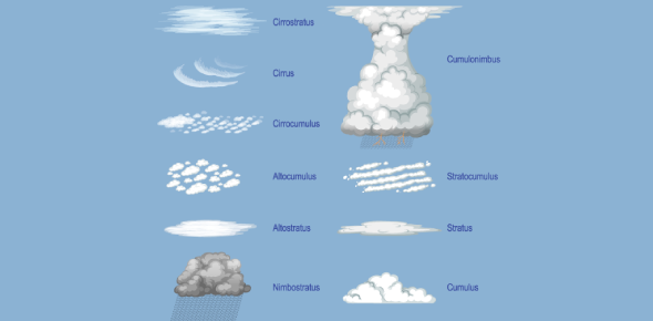
What Are the Types of Clouds?
Clouds are classified based on their appearance, altitude, and formation process. Meteorologists group clouds into four main types, each with subcategories, depending on how high they form in the atmosphere and what weather they signal. Understanding these cloud types helps us interpret current conditions and predict changes in the weather.
High-Level Clouds (Above 6,000 meters or 20,000 feet)
These clouds form in the upper troposphere, where temperatures are very low. They are composed mostly of ice crystals and appear thin and wispy.
- Cirrus (Ci):
Thin, feathery clouds with a hair-like appearance. They often indicate fair weather but may signal an approaching warm front. - Cirrostratus (Cs):
Transparent, veil-like clouds that cover the sky and often produce a halo around the sun or moon. - Cirrocumulus (Cc):
Small, white patches arranged in rows, resembling fish scales-commonly called a mackerel sky.
Mid-Level Clouds (2,000 to 6,000 meters or 6,500 to 20,000 feet)
These clouds are composed of water droplets, ice crystals, or a mixture of both. They tend to be denser than high-level clouds.
- Altostratus (As):
Gray or blue-gray clouds that usually cover the whole sky and may bring light rain or snow. - Altocumulus (Ac):
White or gray, puffy clouds often seen in groups or layers. They may indicate unsettled weather or thunderstorms later in the day.
Low-Level Clouds (Surface to 2,000 meters or 6,500 feet)
These clouds are composed mostly of liquid water droplets and are the most closely tied to daily weather patterns.
- Stratus (St):
Flat, uniform gray clouds that resemble fog but don't touch the ground. They may bring drizzle or light mist. - Stratocumulus (Sc):
Low, lumpy clouds that can cover the sky in patches or waves. They rarely produce precipitation. - Nimbostratus (Ns):
Thick, dark gray clouds associated with steady rain or snow. These are continuous rain-bearing clouds.
Vertical Development Clouds
These clouds grow vertically due to strong upward air currents and can extend through all cloud levels.
- Cumulus (Cu):
White, fluffy clouds with a flat base. Often associated with fair weather, but they can grow larger and turn into storm clouds.
- Cumulonimbus (Cb):
Towering thunderstorm clouds that can reach the stratosphere. They bring heavy rain, thunder, lightning, hail, and even tornadoes.
Special Cloud Forms (Less Common but Scientifically Recognized)
- Lenticular Clouds:
Lens-shaped clouds formed near mountain ranges. They often look like flying saucers. - Mammatus Clouds:
Pouch-like formations hanging under cumulonimbus clouds. They often follow severe thunderstorms. - Contrails:
Artificial clouds formed by aircraft at high altitudes.
Take This Quiz

How Are Clouds Classified?
Clouds are classified based on three main factors: their altitude, appearance (form), and vertical development. This classification system helps meteorologists identify cloud types, predict weather patterns, and understand atmospheric processes.
1. Classification by Altitude
Clouds are grouped into three altitude levels, depending on how high they form in the troposphere:
High-Level Clouds
- Altitude: Above 6,000 meters (20,000 feet)
- Examples: Cirrus (Ci), Cirrostratus (Cs), Cirrocumulus (Cc)
- Features: Thin, wispy, composed mostly of ice crystals
- Weather Association: Fair or changing weather
Mid-Level Clouds
- Altitude: Between 2,000 to 6,000 meters (6,500 to 20,000 feet)
- Examples: Altostratus (As), Altocumulus (Ac)
- Features: Dense, gray or white, made of water droplets and ice
- Weather Association: Indicate potential precipitation or storms
Low-Level Clouds
- Altitude: Surface to 2,000 meters (6,500 feet)
- Examples: Stratus (St), Stratocumulus (Sc), Nimbostratus (Ns)
- Features: Thick, layered, primarily water droplets
- Weather Association: Fog, drizzle, continuous rain
2. Classification by Form
Clouds are further classified based on their shape and structure into four basic forms:
Cumulus (Heap-Like)
- Appearance: Puffy, cotton-ball clouds with flat bases
- Vertical extent: Can grow tall (as in cumulonimbus)
- Weather: Usually fair weather unless vertically developed
Stratus (Layered)
- Appearance: Uniform, grayish clouds that often cover the sky
- Horizontal spread: Broad and flat
- Weather: Overcast skies, light drizzle or mist
Cirrus (Feathery)
- Appearance: Wispy, thin strands high in the sky
- Composition: Ice crystals
- Weather: Often indicate a change in weather
Nimbus (Rain-Bearing)
- Not a standalone form but a qualifier used when a cloud produces precipitation
- Example: Nimbostratus, Cumulonimbus
- Weather: Continuous rain or storms
3. Classification by Vertical Development
Some clouds are categorized by their vertical growth rather than altitude alone.
Cumulus Clouds
- Vertical range: Low to mid-level
- Indicate rising air and fair weather
Cumulonimbus Clouds
- Vertical range: Low to high (can reach the stratosphere)
- Weather: Thunderstorms, lightning, heavy rain, hail, and sometimes tornadoes
Special Cloud Classifications
Some cloud types are classified by unusual shapes or atmospheric conditions, including:
- Lenticular clouds: Lens-shaped, form near mountains
- Mammatus clouds: Bulging, pouch-like structures beneath thunderstorm clouds
- Noctilucent clouds: Glow after sunset at very high altitudes
- Contrails: Artificial linear clouds formed by aircraft
Take This Quiz
How Is Cloud Identification Done
Cloud identification is the process of observing and classifying clouds based on their appearance, altitude, structure, and weather behavior. Meteorologists and trained observers use a combination of visual cues, instruments, and satellite data to determine cloud types accurately. This helps in understanding weather patterns and forecasting conditions more reliably.
Observation by Eye (Visual Identification)
The most common method of cloud identification is direct visual observation. Skilled observers look at features such as:
- Shape and form: Puffy, layered, wispy, towering, etc.
- Color: White, gray, dark gray
- Texture: Smooth, fibrous, or patchy
- Movement: Speed and direction of cloud motion
- Position in the sky: How high or low the cloud appears
Examples:
- Puffy, bright white clouds with flat bases are likely cumulus.
- Thin, feathery clouds high in the sky are probably cirrus.
- Thick, dark clouds that cover the sky and bring steady rain are nimbostratus.
Altitude Estimation
Clouds are also identified by estimating their altitude. This helps narrow down the category-low, middle, or high-level cloud.
Observers use:
- The angle of elevation
- Nearby landmarks (for reference)
- Knowledge of typical heights for each cloud type
Example:
If a cloud appears very high and thin, it's likely a high-level cloud such as cirrus or cirrostratus.
Weather Clues and Precipitation
Weather conditions help confirm cloud types:
- Light drizzle or fog: Usually stratus
- Sudden downpours: Likely cumulonimbus
- Steady rain or snow: Nimbostratus
- Halo around the sun or moon: Cirrostratus
By correlating weather activity with cloud appearance, observers can make accurate identifications.
Use of Instruments
In addition to visual observation, meteorologists use tools to assist in cloud identification:
- Ceilometers: Laser-based devices that measure cloud base height.
- Weather balloons (radiosondes): Collect temperature and humidity data to determine cloud formation zones.
- LIDAR and radar: Detect cloud density, moisture content, and vertical structure.
- Thermometers and hygrometers: Help assess dew point and condensation levels.
Satellite and Remote Sensing
For large-scale or inaccessible regions, satellite images provide cloud data from above Earth's atmosphere. Satellites can identify:
- Cloud coverage and extent
- Cloud type and altitude
- Cloud temperature (infrared imagery)
- Storm development (e.g., hurricane tracking)
Geostationary satellites (e.g., GOES) give real-time data, while polar-orbiting satellites provide detailed snapshots of cloud structure and movement.
Cloud Charts and Atlases
Meteorologists use cloud classification charts and the International Cloud Atlas-a global reference published by the World Meteorological Organization (WMO)-to match observed clouds with standard descriptions and photos.
These resources describe all ten main cloud genera and their species and varieties, allowing for precise and standardized cloud identification across the world.
Take This Quiz
(242).webp)
Conclusion
In this Types of Clouds lesson, you have learned about the formation processes, classification, and significance of various cloud types. From high-altitude cirrus clouds to towering cumulonimbus clouds, each type provides insights into weather patterns and atmospheric conditions.
Rate this lesson:
 Back to top