Latitude and Longitude Lesson: Practical Mapping Techniques
Lesson Overview
- What Are Latitude and Longitude?
- How to Read Latitude and Longitude on a Map
- Why Understanding Latitude and Longitude Matters?
- Conclusion
What Are Latitude and Longitude?
Latitude and longitude are like a giant grid that helps us find any place on Earth. Imagine Earth as a big ball with lines drawn on it, both horizontally and vertically. These lines form a coordinate system that allows us to pinpoint exact locations.
Latitude: Horizontal Lines
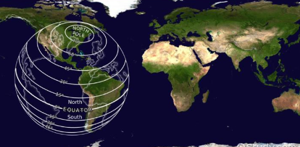
Let's start with latitude. Latitude lines run horizontally around the Earth and measure how far north or south a place is from the equator.
- The Equator
The equator is the starting point for measuring latitude and is at 0 degrees (0°). It divides the Earth into the Northern Hemisphere and the Southern Hemisphere - Degrees of Latitude
Latitude is measured in degrees (°), with the equator at 0°. If you move from the equator towards the North Pole, you go through degrees of latitude: 10°N, 20°N, 30°N, and so on until you reach 90°N at the pole. The North Pole is at 90° north (90°N), and the South Pole is at 90° south (90°S).
Think of it this way: if you're standing on the equator, you're at 0° latitude. If you travel straight north to the North Pole, you'd pass through 90° of latitude.
| Cool Fact: The longest line of latitude is the Equator, which divides the Earth into the Northern and Southern Hemispheres. |
Longitude: Vertical Lines
Now, let's talk about longitude. Longitude lines run vertically from the North Pole to the South Pole and measure how far east or west a place is from the Prime Meridian.
- The Prime Meridian
The Prime Meridian is at 0 degrees (0°) longitude and runs through Greenwich, England. It divides the Earth into the Eastern Hemisphere and the Western Hemisphere. - Degrees of Longitude
Longitude is also measured in degrees, with the Prime Meridian at 0°. The lines run from 0° up to 180° east (180°E) and 180° west (180°W).
Imagine you're standing at the Prime Meridian. If you move east, you'd pass through 10°E, 20°E, 30°E, and so on until you reach 180°. Moving west, you'd go through 10°W, 20°W, and so forth up to 180°W.
Combining Latitude and Longitude
When you combine latitude and longitude, you get a set of coordinates that tell you exactly where a place is on Earth. It's like giving an address with two parts: one for north-south and one for east-west.
For example
The coordinates 40.7°N, and 74.0°W point to New York City. This means it is 40.7 degrees north of the equator and 74.0 degrees west of the Prime Meridian.
Calculating with Coordinates
Let's do a bit of calculation to understand this better.
- Latitude Calculation
To find out how far north or south a place is, you start at the equator (0°) and count degrees up (north) or down (south). For example, if you're at 30°N, you're 30 degrees north of the equator. - Longitude Calculation
To find out how far east or west a place is, you start at the Prime Meridian (0°) and count degrees left (west) or right (east). For example, if you're at 60°W, you're 60 degrees west of the Prime Meridian.
| Real-Life Example Your smartphone uses GPS, which relies on latitude and longitude, to tell you exactly where you are. If your phone shows coordinates of 34.05°N, 118.25°W, you're in Los Angeles. This means you're 34.05 degrees north of the equator and 118.25 degrees west of the Prime Meridian. |
Take This Quiz

How to Read Latitude and Longitude on a Map
Reading latitude and longitude on a map can seem tricky at first, but it's quite straightforward once you get the hang of it.
Here's how you can do it step by step
Step 1: Understanding the Map Grid
A map has a grid made up of lines of latitude and longitude
- Latitude lines (parallels) run horizontally and are labeled with numbers along the sides of the map.
- Longitude lines (meridians) run vertically and are labeled with numbers along the top and bottom of the map.
These lines create a grid that helps us find specific locations.
Step 2: Finding Latitude
- Locate the Equator
The equator is at 0° latitude and divides the Earth into the Northern and Southern Hemispheres. Latitude lines are parallel to the equator. - Identify Latitude Lines
Look at the numbers along the sides of the map. These numbers represent degrees of latitude. The numbers increase as you move away from the equator.
- North of the Equator
Latitude lines are labeled with "N" for north. For example, 20°N means 20 degrees north of the equator. - South of the Equator
Latitude lines are labeled with "S" for south. For example, 20°S means 20 degrees south of the equator.
- North of the Equator
- Find Your Latitude
To find a specific latitude, look at the closest latitude lines and estimate the position between them. For example, if you're looking for 15°N and you see lines for 10°N and 20°N, you know 15°N is halfway between them.
| Fun Fact: The Prime Meridian in Greenwich, England, is where time zones start. It's also a popular tourist attraction! |
Step 3: Finding Longitude
- Locate the Prime Meridian
The Prime Meridian is at 0° longitude and runs through Greenwich, England. It divides the Earth into the Eastern and Western Hemispheres. - Identify Longitude Lines
Look at the numbers along the top and bottom of the map. These numbers represent degrees of longitude. The numbers increase as you move away from the Prime Meridian.
- East of the Prime Meridian
Longitude lines are labeled with "E" for east. For example, 30°E means 30 degrees east of the Prime Meridian. - West of the Prime Meridian
Longitude lines are labeled with "W" for west. For example, 30°W means 30 degrees west of the Prime Meridian.
- East of the Prime Meridian
- Find Your Longitude
To find a specific longitude, look at the closest longitude lines and estimate the position between them. For example, if you're looking for 45°W and you see lines for 40°W and 50°W, you know 45°W is halfway between them.
Step 4: Combining Latitude and Longitude
Now that you know how to find latitude and longitude separately, you can combine them to pinpoint a location.
- Find the Latitude
Locate the latitude line on the map and draw an imaginary horizontal line from it. - Find the Longitude
Locate the longitude line on the map and draw an imaginary vertical line from it. - Pinpoint the Location
The point where these two lines intersect is the location you're looking for.
| Example: Finding New York City Latitude: New York City is at approximately 40.7°N. Find the line labeled 40°N and estimate a bit above it to 40.7°N. Longitude: New York City is at approximately 74.0°W. Find the line labeled 70°W and estimate a bit to the left to 74.0°W. Intersection: The intersection of these two lines is where New York City is located on the map. |
Take This Quiz
Why Understanding Latitude and Longitude Matters?
Understanding latitude and longitude is essential for several reasons that impact our daily lives and global interactions
Navigation and Travel
- Latitude and longitude help us pinpoint exact locations on Earth, whether we're navigating by land, sea, or air.
- GPS systems use these coordinates to provide accurate directions and help us reach destinations efficiently.
- In emergencies, knowing your latitude and longitude can save time for responders to locate and assist you quickly.
Geographic Awareness
- Learning latitude and longitude enhances our understanding of global geography and spatial relationships.
- It allows us to read and interpret maps effectively, making travel and exploration easier and more informative.
Scientific Research
- Scientists use latitude and longitude to track environmental changes, study wildlife habitats, and monitor climate patterns globally.
- Astronomers use celestial coordinates based on Earth's latitude and longitude to study celestial bodies and phenomena.
Global Connectivity
- Latitude and longitude provide a universal method for communication and coordination across borders.
- Businesses use these coordinates for logistics, shipping routes, and global trade networks.
Educational Importance
- Teaching latitude and longitude in schools promotes geographic literacy and cultural understanding.
Knowledge of latitude and longitude opens doors to careers in geography, navigation, environmental science, and urban planning.
| Fun Fact: The latitude and longitude of the Statue of Liberty in New York City are approximately 40.6892° N, 74.0445° W. |
Take This Quiz

Conclusion
Now you understand how latitude and longitude help us know exactly where we are on Earth. Latitude lines run horizontally, like the steps of a ladder, and tell us how far north or south we are from the Equator. Longitude lines run vertically, like the sides of a ladder, and tell us how far east or west we are from the Prime Meridian. Together, these lines create a grid that helps us find any place on the planet.
By using coordinates, we can locate cities, countries, and even our own homes! This system is like the world's address book, making it possible for travelers, sailors, and even space explorers to navigate accurately. Learning about latitude and longitude opens up a world of exploration and adventure, allowing us to understand maps and globes better and appreciate the amazing geography of our planet.
Rate this lesson:
 Back to top